
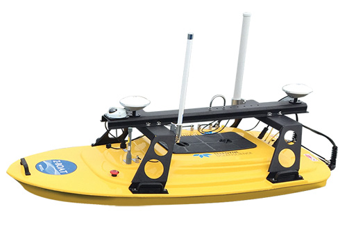

Z-Boat 1800
Product descripton: Z-Boat 1800 by Teledyne Marine
The Teledyne Oceanscience Z-Boat 1800 is a rugged remotely operated surface vehicle (USV) designed for high-resolution shallow-water hydrographic surveying in areas where conventional survey vessels are impractical, unsafe, or unavailable. Its modular architecture and interchangeable sensor well enable flexible integration of multiple payloads, including singlebeam, multibeam, side scan sonar, LiDAR, and ADCP systems.
The Z-Boat 1800 provides a cost-effective alternative to deploying larger workboats or vessels of opportunity, allowing operators to collect detailed bathymetric and geospatial data from shore or remote locations. Advanced radio telemetry enables reliable remote operation with real-time access to survey data, while optional autonomous operation and onboard data logging expand mission flexibility.
Designed for compatibility with industry-standard acquisition systems, the platform supports a wide range of survey sensors and allows quick payload changes from beneath the vehicle. Its modular deck structure provides additional mounting options for antennas, cameras, and other equipment, making it suitable for complex shallow-water mapping missions.
The Z-Boat 1800 supports integrated GNSS positioning and heading information for accurate navigation and can process survey data in real time through compatible software solutions.
Key Applications
- High-resolution shallow-water hydrographic surveys
- Multibeam bathymetry mapping
- Singlebeam depth surveys
- Side scan sonar operations
- LiDAR coastal mapping above and below the waterline
- ADCP measurements
- Coastal and nearshore mapping
- Surveys in hazardous or inaccessible areas
Technical specifications
| Parameter | Specification |
|---|---|
| Vehicle Type | Remotely operated surface vehicle (USV) |
| Primary Function | Shallow-water hydrographic surveying |
| Deployment | Two-person portable deployment |
| Weight | Under 150 lb (typical configuration) |
| Maximum Speed | 2.25 m/s (7.4 fps) |
| Operation Modes | Remote operation, optional autonomous operation |
| Data Handling | Optional onboard data logging and real-time data processing |
| Navigation System | GNSS positioning and heading support |
| Sensor Integration | Singlebeam, multibeam, side scan sonar, LiDAR, ADCP |
| Sensor Mounting | Interchangeable sensor well |
| Payload Compatibility | Reson T20 multibeam, Odom MB2/E20, RDI ADCPs, Tritech side scan sonars, and other survey sensors |
| Communication System | Advanced radio telemetry |
| Data Access | Real-time survey data monitoring |
| Software Compatibility | Industry-standard acquisition packages; CARIS Onboard™ real-time processing |
| Additional Features | Modular deck structure for antennas, cameras, and additional sensors |